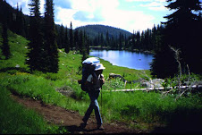
July 5th 2012 - ICT Hunter Transfer Camp to
Willow Creek Rd/ South Fork of the Boise River - Hiking about 16miles in about 9hours 30mins.
Ok no bicycle this time it’s all Shanks Ponies as my Folks always called ‘em. Just
a Day Pack about 20-25lbs of mostly survival gear and of course my walking
sticks. For those of you who don’t hike with Treking poles, an old stick you
carve along the way or something to steady you on the uphill and downhill
sections –“Just get some and try them on one long downhill that’s steep
sometime and then see if you don’t carry some after that”. The hike went smooth
and the trail was easy to follow. From tracks I would say more dirt bikes thru
here than anything else. I can’t complain they keep the logs cut out and the
trail well worn, I must admit sometimes the dirt bikes leave nasty ruts and
loose rocks on the steep sections but it’s all good. If you are on a steeper
section and hear bikes coming, it can be smart to give them a little room. Most
of them are real good people but they might have to be blasting bye to make it
up the section you are on, so step off the trail if you can and wave as they go
bye. I find most are very respectful and only a few jerks give these guys bad
names. The hike up the N Fork Lime Trail
was rather easy with several creek crossing most knee deep or less but you will
get your feet wet unless you do some long jumps or bank exploration. Fill up on
water before hitting the top or you won’t find any water until you get almost
to the S Fork of the Boise River, about the last 6-7 miles. There was one small
drizzle near the top of Trail 037 but it will likely not run for much longer.
The last 3-4 miles down Trail 037 is steep and single track with loose dirt,
gravel and rocks from the dirt bikers, use caution going down this and
definitely get some hiking poles. These steep loose rock sections will hurt you
fast if you don’t take them slow and steady, plan on only making 1 to 1.5 miles
per hour thru here. It can be done faster but you can also roll to the bottom
of the canyon on your head too. This is a good long day hike that will be about
all most people will want in a day. It is also a great assessment hike for me
to see exactly how much mud I got for the upcoming sections that are longer. Came accross a herd of sheep near the top of the drainage and two big sheep dogs that gave a few growls and barks but stayed their distance. Great views from up top before dropping back down to the Boise River.
Friday, July 20, 2012
Sunday, July 8, 2012
Bennet Mtn To Hunter Transfer Camp
June 30 2012- Near Peak of Bennet Mtn Rd to Hunter Transfer Camp aprox 26.5 miles Bicycle and some Walking-3hours 15min. Downhill from top of Bennet Mtn across Highway 20 and onto the Castle Rock Rd small walk but otherwise ride like the wind. Going up Castle Rock had some walking uphills as well but otherwise a nice bike ride.
The Rocks are Amazing and very interesting to see. I could go back here to see those again. Across Pine Featherville Rd a nice change from the dirt for a litle ways. Now thru the Cows and the fine silt dirt that feals like wet cement. Watch out for the Bulls They DO Have the Right-of-Way! No problems at all with the Cows for me. The last couple miles downhill to Hunter Transfer Camp. Goal Score and anotherone bites the Dust.
The Rocks are Amazing and very interesting to see. I could go back here to see those again. Across Pine Featherville Rd a nice change from the dirt for a litle ways. Now thru the Cows and the fine silt dirt that feals like wet cement. Watch out for the Bulls They DO Have the Right-of-Way! No problems at all with the Cows for me. The last couple miles downhill to Hunter Transfer Camp. Goal Score and anotherone bites the Dust.
Tuesday, July 3, 2012
ICT thru hiker 2012
Subscribe to:
Comments (Atom)


