Saturday, September 28, 2013

Trail Work on Marble Creek!

An update from Marble Creek Trail #222- a tributary of the Middle Fork of the Salmon River.

A 4-person crew  from the Selway-Bitterroot Frank Church Foundation started up Marble Creek on the 10th of September 2013 after flying into Thomas Creek Ranch. We spent 8 days working up Marble Creek (working upstream, toward the Thunder Mtn. Trailhead), and are pleased to have cleared most of the trail.

This is the 3rd year in a row the Selway Bitterroot Frank-Church Foundaiton has worked on clearing Marble Creek Trail. The 25 mile section of trail meanders back and forth over Marble Creek many times (roughly 25 creek crossings), and therefore presents many challenges to any hiker or trail crew trying to open the trail. We are very happy with the progress and condition of the trail, however want to give some specific information to assist any potential thru-hikers.

As of 9/18/2013:
- From the Middle Fk. Confluence --> Trail Creek, the trail is in great shape. No down trees and brush is clear from creek crossings.

-Upstream of Trail Creek (roughly 300 yards from Trail Ck. confluence) there is no tread. Brush is extremely thick and users will most likely need to walk adjacent to and/or in the creek. Look for brush opening and tread again on the East side of Marble Ck. The trail crosses the creek twice more before obvious tread develops again (around 1/4 mi downstream of Mink Ck.)

-There are down trees in the burn area that surrounds Buck Creek. The highest concentration of down trees starts at Buck Ck. and continues for roughly 1.5 miles North (upstream).


Some pictures from our work on Marble Creek are below!

One of the many crossings over Marble Creek.

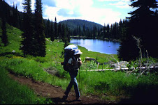
Enjoying the view downstream of Canyon Creek,

A good example of brush overgrown on the trail.

Trail condition post-brushing.

Large tree down on trail.

After clearing.

We even found some creek crossings full of large logs.

But we got them all cleared out!

Overall the trail is in good shape and ready for your visit, so get out there. Marble Creek is a beautiful and remote section of ICT trail in the Frank Church River of No Return Wilderness.

For more information about this project or the Selway Bitterroot Frank-Church Foundation visit the SBFC Foundation website at www.selwaybitterroot.org

Safe Trails!

Seth Norell Bader,
Lead Wilderness Steward, Selway-Bitterroot Frank Church Foundation

Thursday, September 12, 2013

Nevada to Interstate-90

In the summer of 2013, I attempted to hike the Idaho Centennial Trail from Nevada to British Columbia.  I didn't quite make it ... it was so hot and dusty that I stopped at Interstate-90.  Nevertheless, I hiked 699.7 miles in 67 days and identified 202 species of wildflowers.

For more about my trip, look at

http://www.oberlin.edu/physics/dstyer/Backpacking

Friday, July 19, 2013

Grandjean to Atlanta

Three of us took riding and pack stock for the 2 1/4 day trip.  Camped about 4 miles up the trial the first night.  The wolves started howling right across the river from us at about 5:30 am.  They kept it up for almost 3 hours.  The trail got more difficult the higher we got. Mostly logs of various sizes across the trail.  It took all day to get to Spangle Lake.  I would not recommend taking stock that is not VERY used to negotiating off trail terrain.  A large saw is a must in case there's no getting around something.  Beautiful scenery and weather.  Looks like August up there with virtually no snow.  The fish were jumpin' when we got to Spangle that evening.  The next day we took all day getting to Atlanta.  This part of the trail was much better.  Appears that outfitters are keeping it pretty well cleared.  There is one very large tree across the trail above the Flytrip Cr. Trail and another above the Rock Creek Trail that really need to be cut out.  It appeared that few, if anyone, have been through yet this year.  It's hard to find the trail on the other side of the river when you cross it at Rock Creek.  When you cross the river at Rock Creek don't exit the river at the last little section of water...walk downriver in the water about 70 feet and you'll see the trail on the bank.  After that it's pretty clear sailing to the Powerhouse Campground near Atlanta with still some downed trees to negotiate.

Wednesday, January 23, 2013

Clark Fork

another section of my 7 year hike across Idaho.    the ICT goes right through the town of Clark Fork.  


Monday, January 7, 2013

Stateline Trail video


Stateline Trail video

another part of my 7 year Idaho Centennial Trail adventure. 

the Stateline Trail runs along the Idaho - Montana border for approx. 150 miles. 

this is a section of that trail, which I hiked solo in July of 2009. 

this video is actually Part II. Part I is still in the *production* phase. 

This segment is 22 miles between just south of Eighty Seven Mile Peak along the stateline to a point on Dry Creek Road.

http://www.youtube.com/watch?v=SBp3KOg2Asc


Tuesday, January 1, 2013

Gospel Hump part B

I completed another hiking video.  This is part B of the Gospel Hump Wilderness, one of the sections I hiked as part of my Idaho Centennial Trail experience.   in Part A which was titled Buffalo Hump, I hiked with my son Daniel in from the eastern side of the wilderness to Buffalo Hump.   in Part B, my oldest son John and  I hike in from the western side and go almost all the way across the wilderness and back.   from August of 2009  


Ron

http://llamasyndrome.blogspot.com