Hey all--this is Tom from Pocatello. I've been nibbling away at the ICT this spring, and wanted to share some of my experiences. I've nearly completed the route from Murphy to above Stanley, and hope to go a bit further this summer. This is how it's gone thus far:
March 18-20 2016: Hammett to Featherville Highway (60 miles)

Eager to get going on the ICT this spring, I took the Salt Lake Express towards Boise and had them drop me in Hammett (unfortunately, I had them go off at the first exit, which doesn't have an on-ramp!). I walked six miles down through town and to the Snake River bridge where I camped on this mild spring evening.
The next day, charged up for my first solo hike, I covered 29 miles along the ranch roads and finally up into the rocks of the Bennett Hills; once I joined the Bennett Mountain Road, I camped at the Stott Crossing, making a lovely fire for the cooler night.
On Sunday, the snow shoes I had lugged along finally became usefully as the snow began in earnest on the upper reaches of the Bennett Hills and into the Fairfield valley. When I arrived at the Cat Creek intersection on Highway 20, my wife was still far off, so I hiked to the Castle Rock road, which was quite muddy and then snowy, through the amazing rocks, and out toward the Featherville Highway. Lucinda was still not there, so back out to Highway 20 where she picked up at the corrals--another 25 miles!
March 21 2016: Out to the Nevada Line (3 miles RT)

After spending the night in Twin Falls, Lucinda and I went to scout the start of the trail near Murphy Hot Springs (thus eliminating the need to re-do this section in May). We hiked out to the orange marker in the midst of snow squalls, taking three elk by surprise.
May 28-31 2016: The Owyhee Desert (90 miles)

At the end of May, my colleague Jim and I covered the desert from Murphy to the Snake River Bridge, alternating between walking the canyon rim (rough and full of cheat grass) and following the official route (long, hot, and at times overgrown). We managed to get water each day, first making out way to the Poison Creek crossing, where there was a (somewhat off-putting) pool right below the road. On the second day, we followed the official route to Wintercamp (a wearying 28 miles), and were amazed on the lovely river and semi-abandoned farm there. Such a pretty place!
Next day, we again left the official route as it bent northwards and returned to the canyon rim, ultimately descending for water in the Bruneau at the Robeson Trail crossing: the trail is neglected, largely due to a rock slide which was however easily traversable. We then turned back to the route at the Bruneau Overlook. We had thought to camp there, but no satisfactory place presented itself. We ended up camping on the side of the trail in the hard and weedy clay. The subsequent and final day began with another fairly faint bit of trail; this improved as we made our way down into Indian Cove, but the day got hot and the dried cheat grass and dead tumbleweed really called for gaiters. Exhausting!
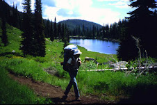
June 6-7 2016: Near Stanley (36 miles)

These days found my patient wife helping me to bag a few sections up by Stanley: that Monday I went from Highway 21 on the Elk Creek trail to Stanley Lake (beautifully maintained, though buggy), and then from Stanley Lake to Grandjean. This involved a number of rather sketchy stream crossings, walking on the snow, and then an ill-advised mile-long bushwhack to avoid a double stream crossing. At the end, I managed to walk past Lucinda's campsite and added 3 miles. The following day's 12 mile walk along the Cape Horn road (through the camas meadows) was relaxing and concluded that section.
June 10-12: Featherville Highway to Atlanta (66 miles)

On June 9, my buddy Mike and I drove to Atlanta (somehow I managed to get my Honda over the steep and rocky James Creek road). We then drove his truck back to the Featherville Highway, after a stop at the pizza shop-rock shop, and camped.
The first day to Hunter Creek and then up the North Fork of Lime Creek was mostly just long--29 miles--but we did appreciate the restroom once we had descended to the campground at Willow Creek. While Grouse Butte was clear, we found Ross Peak to be snow-covered. We enjoyed a nice glissade down the north slope; subsequently, however, we found ourselves picking a path down steep icy slopes, and Mike took a rather scary fall but avoided injury. After about 18 miles, we camped in the Ross Fork Basin. On our final day, we lost the trail at the Mattingly / Alturas Divide (I somehow managed to replace the batteries on my gps with ... the old batteries). Once the snow softened up, we made our way to the wilderness boundary, where the top of the box with wilderness permits was only just visible. Mattingly Creek was glorious; the upper region showed painstaking trail work, but further down the trail was overgrown (one confusing section caused us an unnecessary stream crossing). The final crossing before we headed out to Atlanta was only just doable. Here's to hoping the water goes down for the Atlanta to Grandjean section, which I undertake next week!