Sunday, January 18, 2015

Hwy 20 – Willow Creek C.G.

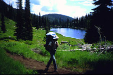
On 8-1-2014 my 10 year old son, my father in law, and I started my next portion of ICT.  Because of my previous bad luck on this trail, and bringing my young son this time, you can bet that I had my stuff together on this trip.  We rode the 19 miles to Hunter Transfer Camp on mountain bikes, with no setbacks.  The Castle Rocks were pretty cool, but we really didn’t stop to admire their awkwardness.  The first two miles were downhill and the last two miles were downhill, but everything in between was a gradual uphill climb on gravel or paved roads.  We took a long good break at H.T.C. then threw our packs on and began the walking express.  We only hiked approximately 4 miles, and camped near Ellis Gulch.  Saw a few deer on the way there, but that was it for the rest of the trip.  As soon as we went to sleep that night, it started raining, and didn’t stop until right before we woke up.  Today’s hike would be approximately 9 miles, and a 2100’ climb.  I don’t know if was from all the rain, but we had to cross the creek approximately 12 times, and about 5 of those crossings were walking through the water.  Have your water shoes and towel handy!  Two miles from the top, there is a sign indicating 2-miles until Grouse Butte, make sure you get water here!!!  This is the last water until you hit the South Fork Boise River.  These last two miles were a little tough, but worth the view on the top.  The next day we walked down five miles to Willow Creek C.G.  This is a 2400’ drop, and got pretty steep in some points.  When we got close to the South Fork Boise River, I’m pretty sure I heard a rattlesnake in the bush, and then saw a dead one on the road along the river.  Keep your head up in this area!  I was pretty disappointed that we didn’t see much wildlife, especially after my wife bought me bear spray, because she wouldn’t let our son come without it.  Well, it now time to get some of this winter sludge off, and get ready for this summer, as I want to get to Dagger Falls before the end of hiking season.  Until next time, be safe out there!

Hwy 20 - Snake River

After almost two years of an absence and one knee surgery, I decided it was time to get back to work on completing the ICT.  So, on 5-31-2014, two friends and I tackled the trail yet again.  This trip would be with Bill and Aaron, Aaron was the buddy who made it to our destination on my first segment.  We last left off at the Snake River, but decided to do this next segment in reverse. We would start our journey On Hwy 20 and proceed southbound rather than north.  So far our ICT journey has brought forth medical evacuations, laughs, tears, and bad trails, so why would this one be any different!?  So I will start this story out at my house, in my driveway loading our mountain bikes.  My bike rack is a Wal-Mart model, it’s not the best, but it does get the job down with some minor bike configurations.  You have to take the seat post out of the bike frame to get all of our bikes onto this rack.  This is no big deal, but it would add to our already story filled journey on this trail.  We get to our starting point and unload all of our bikes and gear.  Aaron and I get our seat post back onto our bikes and are already to go, but Bill is still working on getting his seat post back into his frame.  The seat post goes into the frame, but will not slide down into position.  On any other occasion, we would have brainstormed this issue and figured out the problem, but no, not on our ICT journey!  We had mistakenly thought that due to the elevation and temperature change that his frame had somehow tightened up.  So what do we do, but forcefully push this seat post into the frame of his bike.  It then occurred to us that we must have mixed up our seat post, and Bill was trying to put Aaron’s seat post into his bike frame.  The damage was already done, the seat post wasn’t coming out, and we had no tools to assist us with this issue.  Aaron and I suggested for us to go back home and try again some other day, but not Bill!  Even though he could barely touch the pedals, he wanted to get today’s segment done.  This was supposed to be an easy 5-mile ride uphill then a ton of downhill riding.  Four miles into our trip, Bill said enough, and he couldn't ride like this anymore!  So we put our heads together, got out all tools that we had, and come up with a plan.  Two hours later, and two saw blades completely grounded down to nothing from my multi-tool, we cut through the seat post and lower the seat to a more suitable position.  We get off Bennett Mountain road and start headed cross country to Steen road, but not before we get some lunch.  This cross country portion is pretty technical, and sketchy, but well marked.  Aaron and I are pretty avid bikers and had no problems with this part.  Don’t get me wrong, Bill is probably the most athletic/ in-shape out of the three of us, but today wasn’t his day.  During this portion, he flipped over his handle bars and somehow broke his foot (revealed by x-ray the next day) The rest of the trail is gravel or paved road, but our/Bill’s bad luck wasn’t over.  We had to stop and change two flat tires on Bill’s bike, but the tubes wouldn’t hold air for some reason.  So, we had to stop every 15 minutes to add more air to his tire.  Then after all of our bad luck, we finally finished at the Snake River, Thank God!


Thursday, January 15, 2015

Owyhee Desert pt. 2

On 9-28-2012, my buddy Bill and I continued where some friends and I had finished off last time.  He had actually backpacked from the Nevada State line to the Bruneau Canyon Overlook over three days in the last part of the 2011 summer.  Like my previous bad experience on the first portion of this leg, he too ran into water issues.  Our journey this day would be on mountain bikes, and he didn't mind backtracking and starting at WinterCamp with me.  The first ten miles to the Bruneau Canyon Overlook went well.  We stopped and looked over the edge for a little bit, then continued straight north.  Problem is that you’re actually supposed to travel out to the east to continue on the ICT.  So, after two miles we realized our mistake and had to fix our predicament.  We made it back onto the trail, found the Clover 3 Creek Rd, paralleled the Bombing Range, and were able to see a few fighter jets flying by pretty low.  The ride down in Browns Creek was beautiful, and we didn't have to pedal for almost 4 miles, but then came the suck!  Apparently at this time of the year, every cow in the desert has used this road as a central highway, which doesn't make for a good riding path.  Almost 80% of the road was made up of 4” of super soft dust, which made it impossible for bikes.  A vast majority of our time on our journey was getting the dirt out of our gears and just walking the bikes.  We got to Pothole road and took a long well deserved break.  We continued northbound and met up with our pickup team at the Snake River Bridge on Hwy 78.  So we picked a great day to cover these 35 miles; as we didn't encounter any rattlesnakes, it never hit over 80 degrees, and there was partial cloud cover.     

Saturday, January 3, 2015

I'll be teaching a couple of classes in Community ED evenings this winter:
Long Distance backpacking
 
Lighten your backpack

If you want to read about the Idaho Boundary Trail, go to this page:
http://www.fultek.com/ibt/
and download the Hiker's Guide.
Mike O'Brien