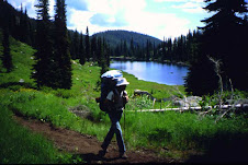
Who has ICT plans for 2010? Starting where and when, which direction and how far? I'm wishing all hikers a great adventure!
Be sure to sign Trail Registers at the Hammett, Mullan, Clark Fork and Naples Post Offices.
Subscribe to:
Post Comments (Atom)
9 comments:
Just finished a mountain bike from the Nevada border to Hammett. The bikes did much better than the support vehicle. The weather was great, the flowers were blooming and the fields were green. What an amazing ride!
May I get info on the resupply options and the guidebook here? I posted a long series of questions last night and it looks like the moderator didn't post it? Maybe it didn't come across? Who knows...
I didn't see your list of questions but info is at http://parksandrecreation.idaho.gov/
The ICT is a dropdown from recreation. Another dropdown from ICT has maps, gps, guides, resupply points, access issues, trail conditions, history and more info that should answer your questions.
Ok I will post the questions again. I am aware of the Idaho Parks and rec website and have found the maps somewhat useful. However I have specific questions about resupply and the ICT guidebook.
First is the guidebook worth the purchase? I read somewhere it was published 10 years ago and no longer accurate for the trail? Does it have specific info on the resupply?
The website you referred me to has a list of possible resupply locations, but no phone #'s, addresses or hours of operation. Nor does it have any info as to how far these locations are from the trail. I am not sure how this list would be useful for mailing packages.
Hammet- Where is the PO? Is it in town or out of it? Is there grocery there? Hotels? Diner?
Grandjean- Same as above and how far off trail
Pistol Creek Ranch- is this private business? If so what is the contact info?
Whitewater Ranch- same as pistol creek for questions.
Mullan- Same as Hammet and Grandjean?
Clark Fork- Same as Hammet, Grandjean and Mullan
Naples- Same as above
I posted these same questions on 6/13. Must not have come across or got approved? Who knows. However as I mentioned above the Idaho Parks site is good for maps and gps waypoint, but that is where the info stops. Was considering purchasing the guidebook, but if it isn't going to help me with resupply or trail description probably not worth the expense for me. Where you able to plan your trip off the Idaho parks site? If so maybe I am missing the above info on the site? Maybe I didn't go to the right part of the site, although I thought resupply is where it would be. Not much info there.
If you have any one has any info on the above resupplies I would appreciate any leads or phone #'s you have. Once I have that I will be out of your hair and walking. Can figure the rest out on my own.
Thanks for your help,
Adam Bradley
ICT was set up to be hiked with vehicle support.
Instead of the guide you will probably either buy FS maps or use a mapping program to print maps. You'll have choices as to a route within or skirting the designated wilderness.
Use Google maps online to for your route, PO and (minimal) services in very small Hammett, Mullen, Clark Fork and Naples. If you take trail, then dirt roads from Calder Mtn to Samuels you will be able to avoid the 12 mile Hwy walk out of Naples. You can resupply and eat very well at Samuels Conoco but you'll miss out on the Naples B&B and laundry.
Arnold Aviation has contact info for Pistol Creek and Whitewater. You walk on private property at Pistol Creek. Whitewater has meals and cabins. Grandjean, about a mile off trail, is a CG with Sawtooth Lodge which also has cabins and meals. None of these has a store.
Between the ICT site and googling towns, POs and Arnold Aviation you can plan your hike. You'll see that you can hitch long distances on slow roads to larger towns if you want.
GottaWalk,
Thanks for the tips! I was able to find everything to get me going off your last reply and I appreciate it so thanks for taking the time to share that.
If I could bother you for another opinion. I think heard about a section of trail that has tremendous blow downs. Any idea of where this particular section is and how far?
getting excited about the ict!
adam
Does the GPS route on the ICT site take into account the private property issues and bypasses? It looks like there are several. Just need to know if I need to pencil these bypasses in on my maps or if it is already taken into account. I'm in training now for my first long hikes and I hope to do the desert postion in October or November from the border to I-84...possibly to Hwy 20 if the weather holds out...then do the remaining trail to the north in stages in 2011. Great site and lots of great information!
just finished approx. 117 miles up in the Hoodoo Pass, Stateline, and Wilderness Gateway areas. I was through there about 2-3 weeks after Marcia was through there. My son-in-law provided vehicle support, although I was solo for 4 days, covering about 73 miles. I have about 91 miles left to complete my ICT journey across Idaho. Will probably not finish until 2011 however. Ron
my wife and I just finished the segment on the ICT West between Rocky Bluff campground and Wind River Bridge at the Salmon River. This was a 21 mile section with about a 4000 foot elevation drop to the river. I now have only 65 miles left to finish the ICT! It will be saved for 2011. -- Ron
Post a Comment