
Monday, October 26, 2015
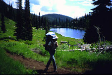
This past summer my girlfriend and I hiked the ICT from Featherville, ID (south of the Sawtooths), north to HWY 12. We had a great adventure and would be happy to answer any questions, general or specific, about trail conditions, resupply ect... The main takeway is that this trail is really more of a route; not at all similar to the PCT in that you'll actually be in the wilds alone and that signage and maintenance are sparse. We did about 12 miles/day and that was certainly tough enough in the jungle gym of the ICT. For naviagtion we used the ICT maps from the Idaho parks site, a compass, and a keen Sacajawea intuition.

Subscribe to:
Post Comments (Atom)
9 comments:
What did you use for resupply point?
We dropped off a package for ourselves @ Stanely lake campground w/the camp hosts.
Sent a package to Indian Creek Gaurd Station on the Middle Fork w/ Arnold Aviation.
Sent a package to White Water Ranch on the Main Salmon w/ Arnold Aviation.
Sent a package to Moose Creek Ranger Station on the Selway w/ Choice Aviation from Hamilton, MT .
I did a thru-hike this summer too. My girlfriend Kelly joined me from Hunter Transfer Camp to Highway 12. What was your timeline? Were you ahead or behind us? Are you from Idaho? (I'm in Boise) Do you want to grab a beer sometime? I'd love to sit down and talk trail with you guys.
Wow we just missed you guys I guess. We left the S FK of the Boise river on June 15th so we had a couple weeks head start. Your video was great, some trail deja vu. I see you met Dave at Indian Creek. Wonderful hospitality on the rivers right. Currently live in the Bitterroot Valley, but used to live in McCall which is where I heard about the trail. I'm happy that someone else hiked the ICT, there were times that we thought we were the only ones. Anyways, cheers to you for a great trip
Dang. I wonder how close we came to running into each other. Had you done any other long trails before the ICT?
Did you guys take any reroutes? We went around the Selway Crags due to a fire. Took N. Fk. Moose Creek to Fish Lake. Other than that we stayed on the trail. I'm curious about alternates through those sections. I've seen some cool ones online.
We often thought we had the trail to ourselves as well. Not many signs of other hikers out there but we always held out hope that we would meet some, haha.
We did take a number of re-routes based on info we got pre-trip from rangers. The most significant was leaving the ICT @ warm springs bar near where the ICT goes up Patrol Ridge. We followed the Running Creek trail to the Selway River then the Selway trail all the way to Moose Creek.
We took the ICT past the junction for Fish LK and went up Rhoda Creek. As others have said the trail is in horrible shape but we did make it...
If you want more specific info for the book i'll be happy to help. Let me know
Just spent the morning looking into that Selway River trail. Looks like a pretty great hike. Did that route take you past any guest ranches or lodges that you got to visit?
Yes a few. Most were private though(maybe all). Also a couple airstrips & a USFS cabin. The Selway River Lodge was gorgeous & right on the trail, however it is private. The Selway trail was great, rugged like the middle fork but more green. Also, the trail is in great condition, best on the whole ICT maintenance wise.
Post a Comment