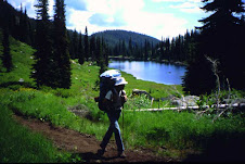
Day 1: 13 miles. Bryan and I set off from the 84 at N. Hammett Hill Road exit at 1:30 p.m. Despite 90-degree temps and relentlessly hot pavement, we got lucky with cool winds, lots of clouds and desert rain showers that made their way around us instead of giving us a good soaking. The trail here is mostly paved and gravel roads, and the trail markers are clearly visible. We saw plenty of wildlife despite the heat, including rabbits, badgers, deer, hawks, pheasant and quail.
Day 2: 16 miles. Set off at 8 a.m. for an all-day, uphill hike into Little Canyon. Great valley views from the surrounding buttes. Climbing out of the valley was finally on-trail, a refreshing break from the noisy, crunchy gravel roads, but it wasn't long before we were back on the road when the trail joined Bennett Mountain Road heading up to Mount Bennett. Lots of cattle out grazing. Sometimes an entire herd was our audience as we passed by. This portion of trail is spectacular this time of year--the flowers are in bloom, the hills are green and the snakes and lizards are sunning themselves. We stopped just short of the summit to make camp and rest.
Day 3: Six miles. Headed out early to take advantage
 of the cool morning air and meet our noon ride at Cat Creek Rd. and Highway 20. We enjoyed great mountain views once we reached the summit. Near the end of the trail, we surprised a few Harley riders who thought they were alone, enjoying a beer. They asked us a lot about the ICT and wished us luck.
You can view all of our photos here. BTW -- Bryan and I are avid backpackers who are taking on the ICT in segments. We're based in Boise and can help anyone seeking assistance/support as they make their way through the southern portion of the ICT. We'll post our own progress as we complete each segment (give us a few years).
