Hi everyone,
This is Leo Hennessy, trail coordinator of the Idaho Centennial Trail, from the Idaho Department of Parks and Recreation. I want to welcome you to this new blog on the Idaho Centennial Trail.
We hope this will be a useful tool for people and public agencies to find out the best information about the Idaho Centennial Trail.
Please feel free to post information, photos and video from your trips on the Idaho Centennial Trail.
We'd also like to use this blog as a forum between trail users, the Forest Service, Bureau of Land Management and Idaho Parks and Recreation to discuss issues related to the Idaho Centennial Trail.
In my mind, the Idaho Centennial Trail is a relatively undiscovered jewel that runs through the best of Idaho's outdoor settings, from the colorful desert in the Owyhee Canyonlands to the Frank Church-River of No Return Wilderness, to the Stateline Trail, to the Cabinet and Selkirk mountains in the Idaho Panhandle.
I hope this blog inspires you to get out there and enjoy the trail.
Leo
skip to main |
skip to sidebar
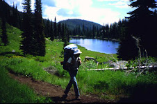
Sid Tate hikes in the Selway-Bitterroot Wilderness
This is an official blog on the Idaho Centennial Trail, sponsored by the Idaho Department of Parks and Recreation. Please feel free to share information about your trips on the Idaho Centennial Trail, to benefit ICT users and trail managers. Let us know about trail conditions, trail access issues, and feel free to post notes, photos or video from your trips.
Let us know if you'd like to contribute
If you'd like to contribute to the ICT blog, please send Leo Hennessy an email at idmtnguy@aol.com and he'll add you to the list of authors. We encourage submissions to the blog so people can hear about your trips and see your photos and video.
Many thanks - Leo
Many thanks - Leo
On the Trail
Sid Tate hikes in the Selway-Bitterroot Wilderness
Contributors
- 1morestep
- 43rd Parallel - John and some VIPs
- BDV
- Claine
- Clay
- Dan Styer
- Dennis Ahern
- Frog Finnegan
- GottaWalk
- Leo Hennessy
- Mike O'Brien
- Paige
- Ron
- Russmiller
- Steve Stuebner
- Steve
- Tom
- Unknown
- Unknown
- Unknown
- Unknown
- Unknown
- Unknown
- Unknown
- Unknown
- Unknown
- Unknown
- dnakker
- dougmetzgar
- gerardocallaghan
- the spatial juan
24 comments:
This is a great idea, and will provide an outlet for those of us *out there* on the ICT to start adding some comments. I have recently hiked on the ICT West from Selway Falls to road 222 on the Red River near Elk City. Meadow Creek trail was in fairly good shape. The climb west from Meadow Creek up to Anderson Butte Lookout is in need of some trail maintenance. The other side is better maintained, probably due to ATV trail access. There was some snow near the top but not impassable. Jerry Finnegan will be able to supply more information on the section continuing west from Red River road to Five Mile campground. Sourdough Peak, we hear, is still inaccessible by road.
Ron Whittaker
My son and I were trying to go up (north) the Idaho Centennial Trail from Lola Trailhead to Thunder Mountain. For the most part the lower end of that trail if fairly good where it follows the river. There are some places where the downfalls needed to be cleared from the trail and the trail needs a little repair but you can get either over them or around them.
There are bears at Sheepeater hotsprings that you do need to be aware of. It is not a good place at this time to spend the night. They can and will get your cache down.
However, when it comes to Marble Creek there is an amazing amount of downfall and flooding up there it is hard to get through and brushy above Big Cottonwood Creek. OH MY! After 8 hours of looking for the trail and trying to climb over, around and through all of the downfalls up there I think we got within 10 miles of Thunder Mountain, but by then we were done. There are downfalls piled up there that are incredible.
Any insights into the Rush Creek Fire near Big Creek and East of the ICT? Was curious if anyone knew more info about this wildfire. At this point it is only ~200 acres, but certainly within striking distance of the trail if it decides to move westward. Any info is appreciated.
Kudos to the efforts made to get this blog up and runnin'. Thanks!
Brian
I plan on starting a hike soon, was going to hit Marble Creek around the middle of August.
If that trail is very hard to traverse, are there recommended alternative routes?
Rex...you might consider Norton Ridge Peak to Shellrock Peak and then along Shellrock Ridge to the head of Marble Creek. While longer in distance and likely quite dry (ridges), it might prove easier than thwacking through Marble.
I have no experience with the rte, but that seems the most logical alt rte to get around Marble.
Will you be traveling N or S? Sounds like you will be out for awhile. Alright! Have fun...
Brian
Thanks, Brian, I'll check that out. I'm hiking south to north, plan on being out for a couple months - starting next weekend.
We just resupplied our son Bart yesterday at Monumental Summit. He started his month-long hike last week at Grandjean. At that time the Rush Creek Fire was in play, so he changed his route from Marble Creek to Indian Creek (our original resupply was Thunder Mountain). Indian Creek is passable, but not maintained - his word was "gnarly." He lost the trail at one point. Between Dagger Falls and Indian Creek he came upon bear sows and cubs twice. Next resupply will be Aug. 9 at Poet Creek. He will finish up at the Lochsa River on Aug. 15.
I am currently out on the ICT as a Southbound thru hike attempt. Currently in Clark Fork, ID. Trail from the Canadian Border to CF is all in fine shape and no real issues...some areas are over grown, but any real confusion lies at trail/rd junctions where active logging is. I did not try to find the trail from Dodge Peak into MacArthur WLR as all locals consulted starred at me blankly...so I opted for the Pack River rd walk into Naples. Trail from Naples to CF is great. A few unmapped jcts with new trail but not too confusing. Recent trail work in Boulder Creek. All trail on the ridgeline from Camden Mtn to Clark Fork is in fine shape. Some ATV use just south of Round Mtn. The descent into Clark Fork DOES drop you onto private property...a few 100 yds of gravel driveway before you find a public rd. I'll be in Mullan in 4 days and will try to report from there as well although most of the next 80+ miles are rds, so I am sure it will be in fine shape although dry.
Does any one know about the Cabin Creek Fire with relation to the ICT?
Lastly, you can read my blog at:
www.ula-equipment.com/ICT
Glad to read that others are out on the ICT as well. Keep those trail reports coming!
Brian
I have a philosophical question about the ICT: I have been doing occasional day hikes from the south end for the past several years, and as of yesterday I've reached the Clover Creek/Three Creek Road junction near the Saylor Creek Bombing Range. Between the state's web site, the Idaho DeLorme atlas, Steve Stuebner's book, and the trail markers in the field, there can be, at times, four different "opinions" of where the trail is. While one can always (usually?) follow the blazes while on the trail, it can make planning one's hikes problematic--which source do you use, given that there are, at times, some huge differences between them? (Case in point: There's even disagreement on which bridge to use to cross the Snake River!) Thoughts, opinions on this anyone?
Chris Anderson
To follow up on Dan and Sue's (my parents') comment:
The biggest obstacle during my four-week trip on the trail has been forest fires. I've been pretty wary of even getting close to the fires, so I had to adjust my route significantly. First, the Rush Creek fire made me decide to go up Indian Creek instead of Marble Creek--pretty far out of the way, and probably unnecessary, but Monumental Summit was a better resupply point than Thunder Mountain anyway.
Second, once I regained the official trail on Lookout Mountain Ridge, I spotted the Cabin Creek fire off of Big Creek. This was too close to the Coxey Creek trail for comfort, so I ended up hiking back along Big Creek to the Big Creek/Monumental Creek/Crooked Creek confluence and going up Crooked Creek and taking the Bismarck Mountain trail to rejoin the official route. I would have been better off just going straight north on Monumental Creek instead of climbing to Lookout Mountain Ridge, especially since the trail up there didn't look like it had been maintained in many years--lots of deadfall to climb over and I even lost the trail entirely a couple times.
After that, the Chamberlain Basin and the Salmon River and on to the Magruder Road was fire-free, with pretty good trails. But I spotted the smoke from the Lynx Meadows fire from the road, and then my mom informed me of the Rattlesnake Bar fire on the Selway near the Moose Creek crossing. I thought about rerouting to the Split Creek bridge instead, but because I was running out of vacation time as well, I decided to skip that section entirely (for this year) and have my folks drive me up to Selway Falls and hike in to rejoin the trail at Sixtytwo Ridge. I think this was a good decision, because I could see the smoke from the Rattlesnake fire from the ridge and there was a pretty thick haze in the Selway ravine. Other hikers were complaining about the smoke there too. The trail from Big Rock Mountain down to Rhoda Creek is in really bad shape--I lost it a bunch of times, and bushwhacking in that thick undergrowth is not fun!
But after that the trails are well-used, and I made it all the way to Wilderness Gateway on the Lochsa with no further difficulties (well, except for the mosquitoes).
I hope this info is helpful for Brian or anyone else out there on this portion of the trail. I should have photos from my trip on my website within the next week or so:
http://www.bartrobinson.com/trips
Chris: I remember being frustrated by the discrepancies between map sources when I was doing the southern portion as well. I only had the DeLorme atlas to go by at the time (2005), and it often didn't match up with the trail markers on the ground. I've since switched to the Benchmark atlas (much better, in my opinion) and Stuebner's book. The situation changes somewhat when you get into the mountains, as the trail markers get much sparser. I remember the markers in the Alturas Lake region pointing to what must be the motorized route, instead of the hiking route. The one and only trail marker I saw this year from Grandjean to the Lochsa was at Stanley Lake, pointing up to the trailhead at the foot of Elk Mountain road. I'd advise getting the Benchmark atlas and using that, which seems to agree with Steubner's book in most places.
Hi to Brian,
I think we met briefly on the trial, just above Missoula Lake, on Aug. 16th. Our dogs played and I mentioned that we had hiked on the trail btwn Little Joe Road to beyound Hoodoo Pass quite a bit over the past 30 years.
I've wondered how you're getting along on your southbound trek and would love to read an account of your journey, if you publish something or have a web site. David
I've been hiking the ICT since 2003, in bits and pieces, as time allows.
This summer I hiked (North to South)from the Selway river to Rocky Bluffs Campground (north of the Salmon, on the ICT west).
Although the trail near both ends was in good shape the middle portion of this segment was badly in need of trail maintenance. I climbed over, under, around and thru hundreds of downed trees. I understand that fighting fires is the Forest Services Number 1 priority (leaving few budget dollars for trail maintenance) but a lot of the trees/brush are not new and have been littering the trail bed for years. I hope that the "light" fire presence in this area this year allows for some dollars to be earmarked for maintenance next summer.
I had been warned of a mud-slide that had wiped out the trail west of John's Creek so I called before leaving to see if an alternate route was suggested. I was assured that "they have spent a ton of time" cleaning up the trail and no detour was needed. Unfortunately, this was not the case. The trail disappeared at the top of the hill and left a long, steep and loose descent with a heavy pack for me to negotiate.
Other than that the trail was scenic and in desperate need of more hikers. (It looked lonely). The more of us that use these trails, the more likely the F.S. is to maintain them.
Leo - good job of signing the ICT in most of the southern parts of the state. But we need to get more signs at junctions. With map datum being 15 years or more old there are many places where a turn is missed because a junction no longer is obvious. When a descrepancy exists between "the book", National Geographic Topo, Delorme and the "leo" map, go with Leo's map. The numbers may not always match the sign posts but it is the most current info available (the book was written in '98, so it is ten years old. Topo is even older and has numerous descrepancies. I take Leo's map and copy it over to Topo).
One descrepancy I found this summer was atop Porter Mountain, S.W. of Elk City. The book says to take trail # 508 as does the ICT marker on the tree atop the mountain. Leo's map says take trail # 844. Although trail 508 is in real good shape south of Porters (as opposed to the mess on the north side), this requires finding and following trail 820 after about 1/2 mile. This is not a good thing! Leo's trail #844 is longer, but it has to be a better choice until someone reestablishes #820.
i'm glad to see this blog open so we can share info from "on the ground" observation. It's always more accurate than other data.
Go hike, be happy!
first a little back-story: when Jerry (Frog) Finnegan, Nick Abshire, and I were on the ICT in northern Idaho in summer 2006, we met Chris Harrington, who finished his ICT hike that year, near the Lunch Peak Lookout. Chris was using a backpack made by ULA Equipment.
That's the tie-in to this story. The guy who runs ULA Equipment, Brian Frankle, this summer completed his thru hike of the Idaho Centennial Trail from north to south.
I have seen a couple of posts from him on this website. Now he has finished. Great job, Brian! I'm sure many people are happy about the increased exposure for the ICT.
Here is the link to his website:
http://www.ula- equipment. com/idahocentenn ialtrail/ index.htm
and his photo album, recognize any of these places???
http://picasaweb. google.com/ briansbliss/ IDAHOCENTENNIALT RAIL#
Ron (60% of ICT done)
I am planning a through hike of the ICT in 2010 and my regular pack buddy has backed out so concider this as a personal ad for back country company. I'm 28, male, single and prefer averaging 12-20 miles per day.
I am planning a through hike of the ICT in 2010 and my regular pack buddy has backed out so concider this as a personal ad for back country company. I'm 28, male, single and prefer averaging 12-20 miles per day. If you are interested in joining me in 2010 or would just like to make friends for other hikes let me know. good hiking; Dane
I've hiked several small portions of the ICT all up'n'down the state over the last few years and hope to cover the entire length in 2010. Over the next several months I plan on alt. routes to help me bypass more hot springs and air stips along the way. I haven't yet decided which direction to go and that segways me to my alt. purpose to joining in on this blog; My packing buddy has backed out on me and I am in search of some adequate company for this or other trips to come, if you or someone you know might be interested please respond and if this is not the best place to seek such companionship help me if you can to find a better place. Dane
Hi all.
I grew up in Hagerman, and am super fascinated with the southern section of the trail, from the Nevada border to Hammett. How difficult is this section? It seems like caches and knowing where to find water are critical. I would love to know more about this section, people's experiences, and when and where folks might be hiking this section.
Keatonwilson said: "how difficult is it" (the desert section between Nevada and Hammett)
Ron Whittaker and I hiked Nevada to Winter Camp (March 2005) and Winter Camp to Hammett (April 2006). We stashed water at the river access road where it crosses the ICT just south of Bengoechea Cabin and were dry by the time we got there (even in March the desert is DRY). We refilled at Winter Camp (dependable water). Because we did it as a separate outing we did not have a water problem on the rest of the route. If you are thru-hiking you may want to take an extra bottle because I believe the next water source is the Snake River. (We did not go into private water tanks but there are a couple of those along the way. ASK FIRST.
The trail is well signed (thanks Leo), easy to follow and in good shape (except the hardened hoof-prints left by the many cattle that range here. If it is frozen and/or dried, it will shake your teeth loose on a mountain bike and make you pray for no twisted ankle if you're hiking). the trail CAN be driven with a 4WD but only if it is dry (The desert floor becomes a sticky, gooey mess when wet that sticks to everything).
What is the speed record for the trail? I would like to set a new one.
I just returned home from a trip up the southern 120ish miles on the ICT. I rode my mountain bike with a trailer and camping through the Owyhee desert and then two half-day bike trips with car support up to US20. Here are some notes:
Excellent trail signs all along the way. A few time I thought I should make a turn according to the contours on the map but I kept on until I saw the sign posts. There are several gates through the Owyhee desert and some hard more difficult than others to open and close! We encountered many cows along the trail and they stared at us long and hard. Some had to be encouraged to move off the trail. Some followed us along behind like they were herding us! And then some just had to be walked around as they were too stubborn to move. The desert was so flat that it was hard to judge by the contour lines exactly where we were, except for when near the Jarbridge or Bruneau Canyons of course. But the mileage markers on the maps were spot on. A few notes on the maps:
Map 4: There is a Cabin indicated along the trail but I didn’t see a thing. We camped just past that spot on the first night and it was a very nice vista.
Map 6: The East Fork Bruneau was the only water source, and it was quite a marsh after crossing the bridge. The road was flooded in many places but only one place was not ridable by mountain bike – even with a trailer. I was worried about biking across this side canyon but it was easily passable.
Map 8: Crowbar Gulch was quite a haul to get up and out of. And the road just past before the Clover Three Creek crossing was barely distinguishable. However, again the signs were great.
Map 9: The ride down Browns Gulch was a fun downhill cruise and welcome relief from the high desert.
I rode into Hammett but then caught a ride to Glen’s Ferry and back northwest to Bennett Mountain Road, which I took nearly all the way to Highway 20, bypassing the cross country section that didn’t look passable by mountain bike. This road was quite a grind on the bike but the vista at the top was fantastic. It was also the first time I found a tree to sit under and enjoy some shade!
Map 11: Stone Rd has a new name… but I can’t remember what it was.
Map 12: The final mile connecting to US 20 is on Cat Creek Rd. My road map had it labeled Canyon Creek Rd.
Notes on a few sections in North Idaho: the trail and route finding between FR1013 and Lionhead State Park on Priest Lake is great. I did this section on a mountain bike with a trailer. The only difficulties were a stream crossing and one steep section. I drove the paved road along Pries Lake and also the forest road up to the Hunt Lake trail head (4WD needed at the top). On the hike to Hunt Lake follow the orange flags on the trees rather than the red spray paint on the rocks for a much easier tread. On June 12 there was still snow around Hunt Lake and the ridge over to Fault Lake was not passable due to snow. Two weeks later I drove to the trailhead to Fault Lake along Pack River Road and hiked the 6 miles to Fault Lake and up to the ridge top headed into Hunt Lake. There was still patches of snow but at this time the bushwack between the lakes was passable.
Looks like its been over 3 years since the kast post here....but just in case someone else peaks their head in. Im looking for a decent set of maps I can use on my upcoming S to N ICT hike. Good resupply points?
Shaugn; welcome to the group. the post you commented on is from 2008. If you look in the lower right corner there are archives for 2009 through 2012. This is a good website to get information.
you can find topo maps on the Parks and Rec website http://parksandrecreation.idaho.gov/centennial-trail-map
this is a good starting place. Re-supplies can be a challenge on this trail. it only goes through 2 towns for the whole state. Road crossings and ranger stations have been used by other hikers.
Ron
http://llamasyndrome.blogspot.com
Post a Comment