
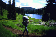
For those of you who are yearning to plan a trip on the Idaho Centennial Trail, or if you're just curious about what it is, check out the new web pages on the Idaho Centennial Trail on the Idaho Department of Parks and Recreation web site.
The web site has a ton of information and photos about the Idaho Centennial Trail, how the trail was created, where it goes, what trail uses are allowed, how to find the best trail maps for the ICT, notes on resupply points, trail access issues and more. The web site also links to videos from a great program that Idaho Public Television did on the Idaho Centennial Trail.
Since the ICT was created in 1990, there haven't been very many people who have conquered the full length of the trail in one summer. Now there's no excuse ... we've provided the information you need, now you just have to plan a trip, get the time off reserved, and check out the trail.
Have fun!
Best, Steve
5 comments:
This is terrific. idaho's premier trail deserves a blog
This is an excellent blog idea. We will link to your blog from the Kootenai Metroplitan Planning Organization KMPO blog. we get a lot of traffic from Kootenai County and Spokane readers...
I have been studying the North Idaho section of the trail and noticed about 14 or 15 miles follow the east shore road along Priest Lake. The east shore road is a very busy road with a tiny shoulder and the section the trail follows is not even a scenic part of the road that allows one to view the lake. In my view it would be dangerous to hike that far along the road. There are miles of ATV roads, Hiking trails, and logging roads with gorgeous views of the lake and the Selkirk mountains that could be utilized. From Hunt Lake trailhead you could follow these roads, many with great scenery, north and drop down to Lion Head campground to pick up the trail from there and continue on up to the Upper Priest Lake. What is also nice about the network of logging roads up there is they are well marked on the map and just about any car can drive up them without much difficulty to drop food caches. So, to make a long question short; what is the reason for having the trail follow the East Shore Road for 15 miles?
Matt, Thank you for the comment on the East Shore of Priest Lake. The trail route was placed on the paved road along the Lake because we needed a route to approve and did not have to time to scout a route through the Dept of Lands property. The roads you speak of are Dept of Lands logging roads and they will log with out notice and close sections at will. My guess is that the route will have to change yearly because of state logging activity. If you have a good route through the area, I would consider making it the trail. I would need to ground truth it and get approval from the Dept of Lands. Maybe a volunteer from North Idaho would like to scout the area to find the best route.
I would like to bike the trail. Anyone know of a commercial oufit offering that as an option ?.
Post a Comment